

Collection: Osher Map Library Collection
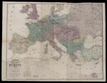
Name: Lloyd's topographical and railway map of the seat of war in Europe, 1870.
Barcode:
Image Number:
Creator:
Publishing Location:
Date/Date Range Produced:
Date/Date Range Published:
Language:
Dimensions: 95 x 121
Physical Description: Map includes a note by the publisher informing the public that "he has actual surveys of the whole of Prussia and France." "These maps are photographed from the Government Survey of each country several years ago, and may be relied on as the only war maps which will be used by Prussia and France in the coming struggle." Also included is an acknowledgement by Adam Badeau who served on Ulysses Grant's staff regarding the reliability of Lloyd's topographical map of Virginia.
LC Call Number: G5701.P3 1870 E2
OCLC: 954161342
Accession Number: OML-1870-49
Donor:
Permanent URL: